
Doug's Mountain Journal
A Chronicle of Natural History on San Bruno Mountain
Doug Allshouse has been writing his seasonal Mountain Journal for many years. We are very pleased to share his reflections on the natural history of the Mountain. Together with David Nelson, he wrote San Bruno Mountain: A Guide to the Flora and Fauna. The book was published by Heyday Books in November 2022 and can be purchased here.
Winter 2023

Teachable moments are few and far between, which means that, when two simultaneously come along, we should take advantage of them. So it was that when six inches of rain fell over thirteen days in December, a powerful atmospheric river would dump five to six inches of rain continuously in a twelve hour period. Those twelve hours changed the geography of Buckeye and Owl Canyons in ways that the 2008 wildfire in those two canyons could not. Prodigious amounts of water and debris consisting of rocks, brush and trees turned serene creeks into tsunamis that unearthed rock many meters below the old ground and sent brush and trees tumbling to the bottom of the canyons. Some of the newly-exposed rocks were noticeably reddish, something we hadn’t imagined. Besides being attractive, what can this coloration tell us about the composition of these rocks? What can they tell us about San Bruno Mountain? We know that the two canyons have experienced mass erosion over the 65 million years since they were created by the deposition of rocks and soils from prior flash floods.
Geologically speaking, the power of erosion was on full display and leaves us wondering just how tall San Bruno Mountain was after it was initially created by tectonic forces. We have rock, in this case greywacke, as a skeleton with muscle and skin made of various soils, which act as a medium for plants of all types to grow on, much like hairs on our bodies. Rain constantly washes the soil away (erosion) exposing the rock to the elements and the process of creating new soil begins. This cycle, over millions of years, whittles away the rock and soils lowering the elevation of the mountain. We know that the Rocky Mountains and the Sierra Nevada were two to three times higher than they are now.
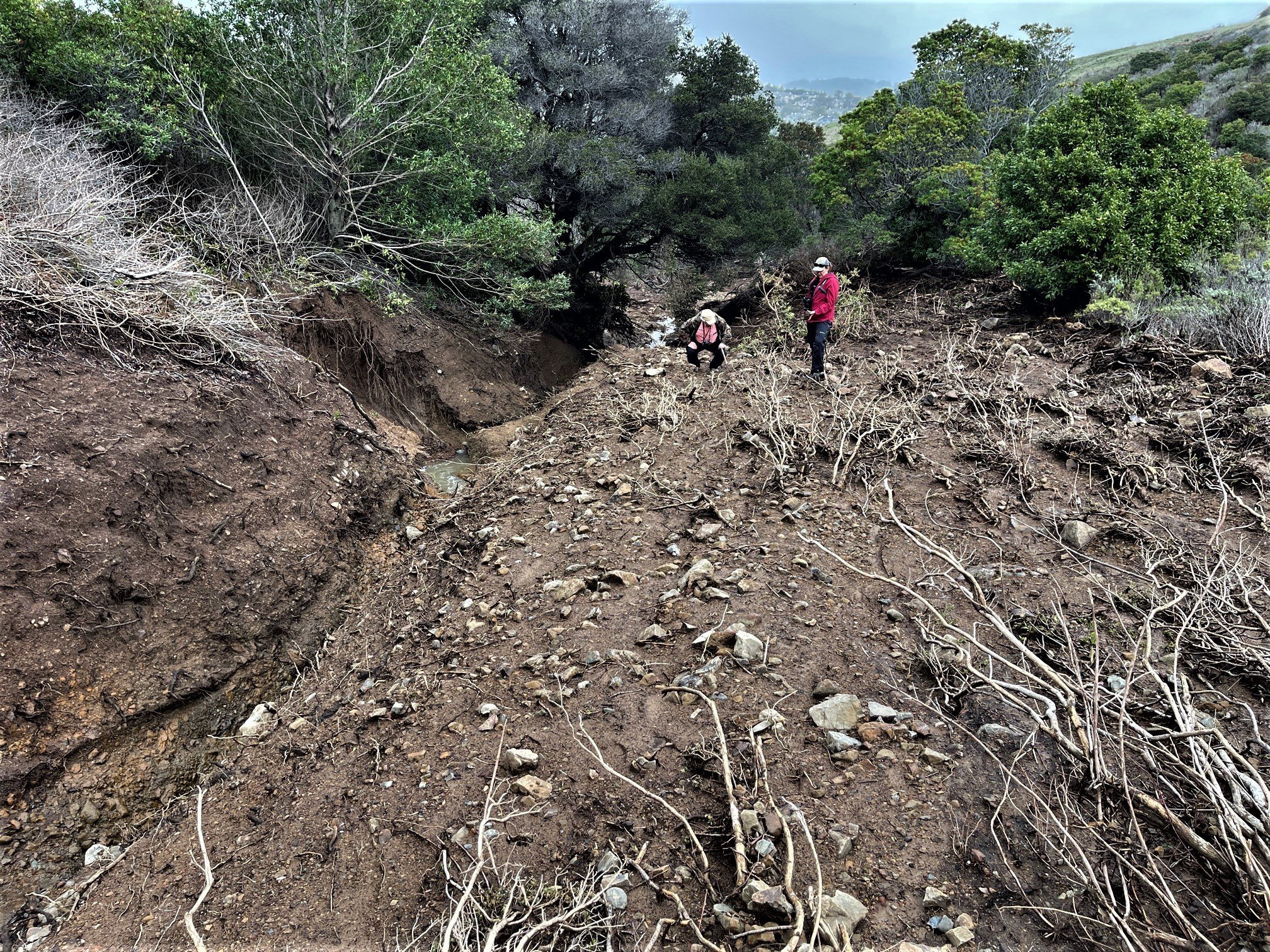
David and Katryn at the debris site
On January 14, David Nelson, Katryn Wiese (Professor of Geology, CCSF), and I spent a few hours hiking up the mudslide in Owl Canyon. What began at the base as a wide, flat plain with many rivulets soon gave way to a wide, shallow U-shape with a dominant creek or two. As we traversed further up the canyon the banks got steeper and the canyon narrower. Just beyond where the mudslide wiped out a forty-foot section of the old trail the slide walls were V-shaped. We walked up the east side onto a fairly-wide section. While David and Katryn talked rocks I walked a bit further up the plain and observed the surroundings. The west side of the gorge showed erosion by the massive chunks of missing soil as if some giant had taken a large spoon and scooped some soil off the deepened creek’s banks. The east side was a wide flat plain and the grasses that remained were pressed flat against the soil. I could easily imagine that water had been flowing over this plain for a day or two since water will take the path of least resistance.
Looking straight down the new creek bed, there were two bay trees side-by-side with the larger tree having exposed roots hanging in midair. A few branches were dangling as well and their leaves were covered in dust. This told us that muddy water had been moving by them as well as the water on the plain. Mon Dieu, we had unraveled the mystery of the event. A debris dam had formed where the bay trees were and water flowed over and around the dam, taking the path of least resistance. Eventually it undermined the debris at the bottom and the dam burst, sending a tsunami of water, rock, tree, and shrub debris down the creek bed, scraping out a new and wider landscape. Ironically, I remembered that in January through March of 2019 (our most recent good rain year) we received 19.34 inches of rain. David, Mark Sustarich and I were hiking up the Owl Canyon trail and there was water crossing over the trail where we had never seen it before. That was the creek on the west side of Owl’s prominent hump rushing to join with the eastside creek as it ran down to Quarry Road. We also did some work on a bay tree that had fallen just beyond the east creek and blocked the trail. Today it is a 35-foot rocky gap stripped of all the vegetation.
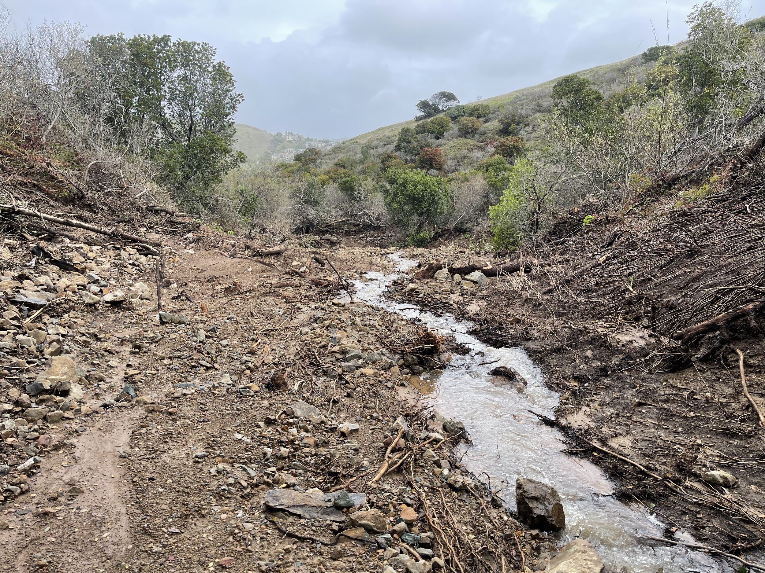
looking down Owl Canyon, south of the debris site
Buckeye Canyon was frightfully similar with destruction washing mud, rocks and tree debris across Quarry Road, downhill to South Hill Drive, and down Old Quarry Road into downtown Brisbane. I hiked up the wash to the shellmound (which was spared the ravages) and took the old trail up the canyon. That was easier on the feet and much more serene while checking out the pink flowering currant bushes, hound’s tongue and lady, maidenhair, and gold-backed ferns. I went as far as I could before facing a huge rock wall and creek bed. At this point, near Three Creeks, a rocky waterfall existed and looking downstream revealed a wide canyon. Looking upstream revealed a narrow rock-strewn creek bed as far as I could see. I think the only way to construct a theory of events would be to attack it from the top.

Looking north

Farthest southerly destination
Just a few weeks past the initial event, cow parsnip was already breaking ground not far from the road—the resilience of nature indeed, not to mention that many willows that were nearly torn from the ground were sporting catkins.
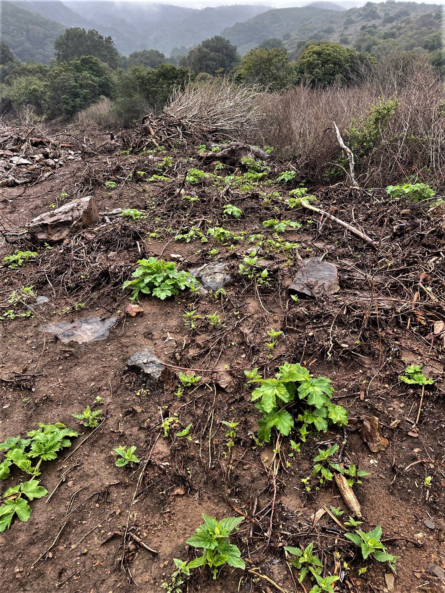
Cow parsnip emerges from soil
Meanwhile, back to my usual morning stomping grounds, I was walking up the day camp road and spied something out of the corner of my eye falling to the ground. I looked over at a carpet of cape ivy and a red-shouldered hawk flew out of the ivy leaves with a vole in its talons and onto to a eucalyptus branch with its catch. I don’t get to see that every day.
Recalling the winter of 2018-2019 in Fog Forest, I remember that we had about a dozen Monterey cypress trees fall over that winter. Most of them were along the day camp road. This winter in Fog Forest it is eucalyptus trees that are falling in bunches. Given the height and girth of these Australian weeds, a really old one can take out another one or two as it crashes to the ground. I have seen nine eucalyptus trees that have bitten the dust this season mostly along the Old Guadalupe Trail, day camp, and day camp road. One cypress tree split its trunk.
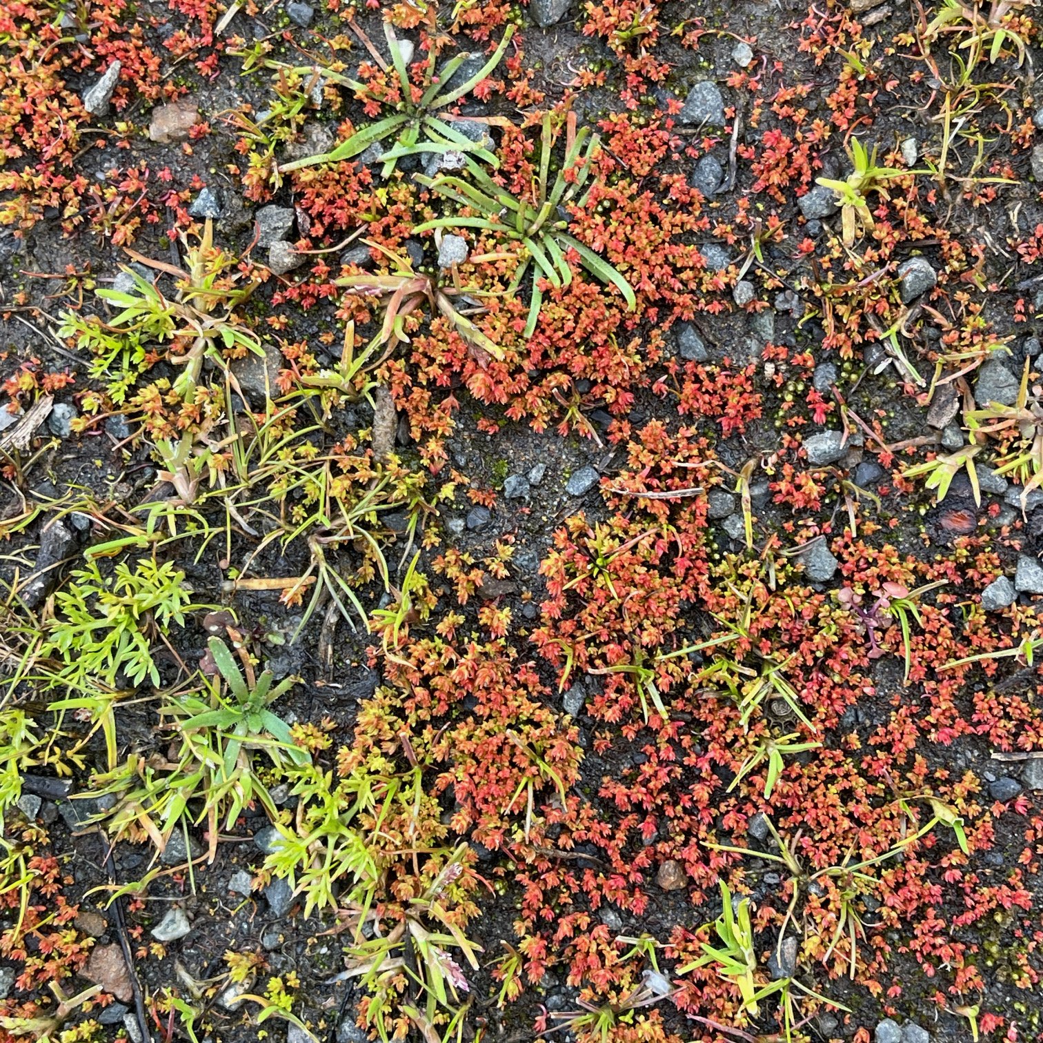
As I was checking out the day camp recently, looking in the little islands of oaks and coyote brush for California Quail, I noticed some sand pygmy weed (Crassula connata) on the ground. This easily-overlooked annual plant is rarely taller than 2 centimeters, less than an inch. It starts life being green in color, but it turns a rusty red with age which is when it becomes conspicuous. Fortunately it grows in large colonies of hundreds of plants. It is not until you look at it through a 10-power hand lens that you discover that it is a succulent in the Stonecrop family. It is related to the larval host plant of our endangered San Bruno Elfin butterfly. Mostly I see it on the Ridge Trail growing in hard-packed soil generally on the road in a slight dip where rainwater accumulates. It has a widespread, but disjunct distribution from western North America to parts of Central and South America.
Spring has arrived and with the plethora of winter storms, cold temperatures, high winds and generally dismal weather it has been difficult imagining the concept of spring. This rain season will go down locally as one of the wettest in many years. 2016-2017 leads with 36.22 inches and followed by 2018-2019 at 29.68 inches. December is usually our wettest month with 13 days for 11.01 inches. January has usually let us down but chipped in an impressive 15 days for 9.13. February gave us 13 steady days for 3.62, and March has given us 14 days for 4.67 inches with storms still on the horizon. Since December 1, 2022 until March 20, 2023 we received 28.36 inches on 55 rainy days. This season is threatening 2016-17 as the wettest year with 32.23 inches and 3 months to go. The snow pack in the Sierra Nevada has blown by the record year of 1982 with more snow on the way! Let’s hope it melts slowly.

On my March hike of Buckeye Canyon, we saw blooms of hound’s tongue, currants, and brittle leaf manzanita. I led the group down Army Road to check out the wildflowers. Nestled within a verdant carpet of grasses were star lilies, California poppies, golden violets, alkali parsnips, buttercups, blue dicks, and silver and varied lupines. Spring has sprung!